

🌄 Five epic routes along Norway's most picturesque roads 🚗
Road trip enthusiasts are in for a treat: Norway is a natural cinema without a curtain. Wherever you turn the wheel, majestic fjords, glaciers and cliffs rise on the horizon, as if created for postcards. But wait, there's more! We've got "premium rows" that'll blow your mind — five spectacular roads that'll give you the best views the country has to offer. Save this list so that one day you can say, "I've driven the most beautiful road on Earth."
How to use the guide
- The brilliant self-drive format! The great news is that all routes are accessible by rental car or campervan!
- The great thing about this is that you can choose the length of the segment! I'm thrilled to tell you that I can show you the exact route, not the whole journey from Oslo. This makes it super easy to fit into any road trip!
- The wonderful world of seasonality! Some roads are closed in winter, so be sure to check the dates before booking your car.
Key to the route: roads Norway — just enter this into your navigation system and it will take you directly to the "Nasjonal Turistveg" sign!
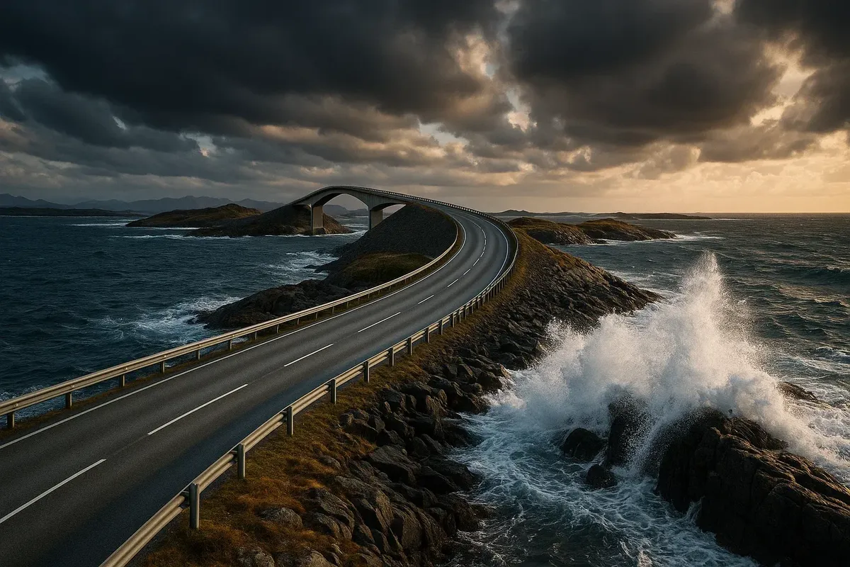
Atlantic Road (Atlanterhavsveien)
Length: 8.3 km | Season: year-round
Why it's epic
Back in 1989, the Norwegians linked a chain of islands with eight bridges, creating a crescent-shaped bend right above the Atlantic. During storms, waves wash over the railings, and in July, porpoises accompany cars as if they were tour guides.
Here are the best spots to catch the views.
- Storseisundet Bridge. This is the "coolest" bridge, which visually breaks off into the sky. Park in the area in front of it.
- Askøbogen Viewpoint. There's a free telescope, wooden terraces and evening sunsets.
Life hacks
- Come at dawn: the road's almost empty, and the first rays of sunlight paint the sea copper.
- If you're after something out of the ordinary, go for stormy conditions (October to March) and watch the ocean from the viewing platforms instead of the road.
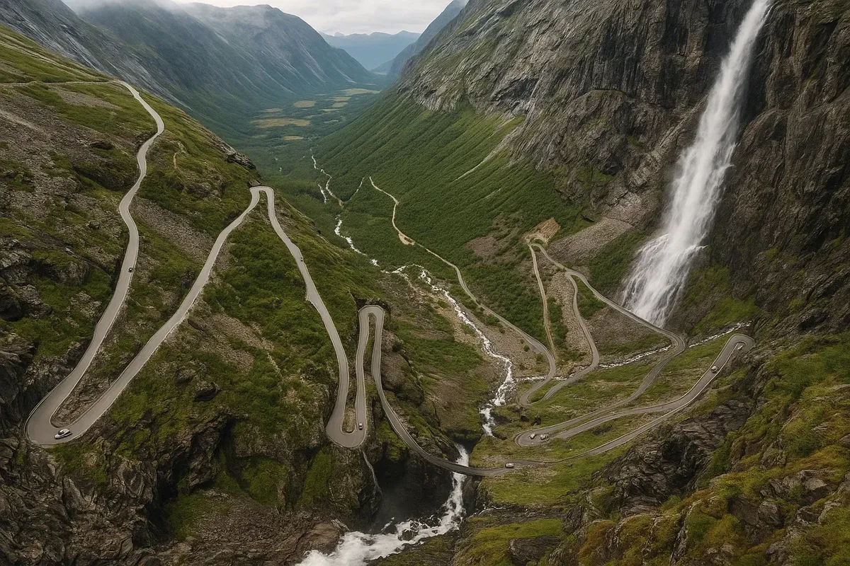
Trollstigen
Length: 18 km of serpentine roads | Season: approximately mid-May to late October
Why it's epic
The road is pretty twisty, with 11 hairpin bends and a 10% gradient. Everywhere you look, it feels like you're driving through a scene from The Lord of the Rings. The Stigfossen waterfall cascades above the road, and you can see Trollveggen, the highest vertical wall in Europe, in front of you.
Here are the best spots to catch the views.
- The Trollstigen Visitor Centre is a great place to find information about the area. You can park for free and walk across the platform to the 'transparent' end, which is over the precipice.
- Gudbrandsjuvet. There are glass galleries above the canyon where you can get great coffee and take some great photos of the raging river below.
Life hacks
- Just a heads-up: when you're climbing, try to keep the gear low so the engine can cool down by braking.
- You should plan your trip to take place between 7 p.m. and 9 a.m. – that's when the buses with tourists are at the hotels.
Sognefjellet
Length: 108 km | Season: late May to October (sometimes closed at night due to avalanches)
Why it's epic
This is the highest mountain road in Northern Europe, at 1,434 metres above sea level. It's called the "roof of Norway" because of its white glaciers, turquoise lakes, moss and dwarf birch trees, which look like something out of a watercolour painting.
Best viewpoints
- The Mefjellet Rest Area is a great place to stop and rest. These futuristic metal "boulders" are both an art installation and a wind shelter.
- Sognefjellshytta. A guest house serving rhubarb pie: the perfect snack when you're out on a glacier.
Life hacks
● Bring a down jacket even in July: temperatures above 5°C are rare.
● There are no petrol stations between Lom and Gaupne — keep your tank at least half full.
Ørnevegen (Eagle Road)
Length: 8 km | Season: April–November (passable in winter, but slippery)
Why it's epic
The Eagle Road is a steep climb with 11 hairpin bends from Geirangerfjord to Eidsdalen plateau. At the top is the Ørnesvingen viewpoint: Geiranger looks like a toy below, with the Seven Sisters waterfall glistening in the distance.
Best viewpoints
- Ørnesvingen. Bonus: there's a see-through waterfall that falls from the platform straight onto the road, which makes the photo have this "crystal" effect.
- Flydalsjuvet. If you go a little further down the road, you'll find the famous "trick" of posing on a rock ledge (the official safety zone is fenced off).
Life hacks
● Late evening is the golden hour: the last rays of sunlight illuminate the fjord, and the tourist buses have already gone down.
● During peak season, park your car at the start of the climb and walk 3 km — less traffic and more excitement.
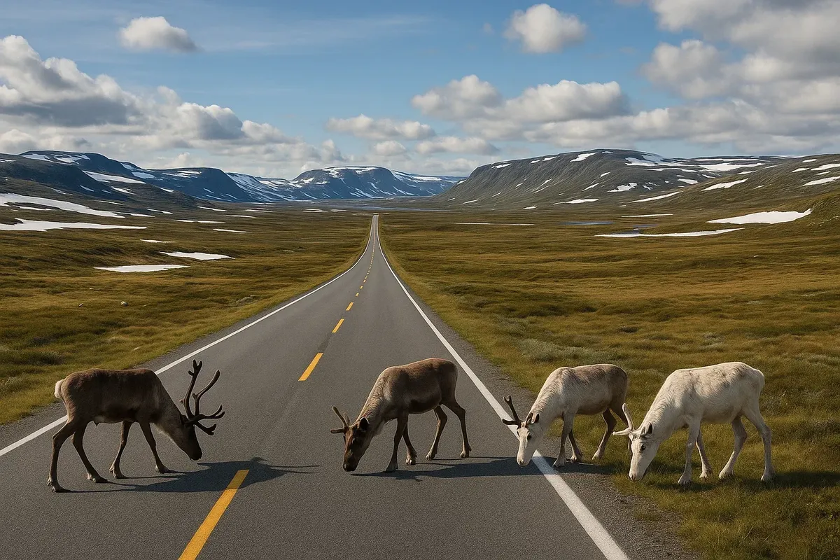
Hardangervidda Plateau (Hardangervidda Scenic Route)
Length: 67 km (along the RV7 highway) | Season: year-round, but whiteouts occur
Why it's epic
Hardangervidda is Europe's largest mountain plateau, with landscapes that look like the Moon, herds of reindeer and horizons that seem to go on forever. The RV7 road goes across it, connecting eastern Geilo and western Aydfjord.
Best viewpoints
- Vøringsfossen. A 182-metre waterfall with a dramatic footbridge over the edge.
- Sysendammen. A huge stone dam with a great view of the Folgefonna glacier.
Life hacks
- In winter, the plateau is often closed for 2–6 hours, so sign up for SMS alerts from Statens Vegvesen.
- In the summer, you should definitely put a trek to the Bukkebreen glacier on your to-do list. It's a 2-hour easy climb and there are no buses nearby.
How to combine everything into one road trip
- Oslo → Hardangervidda → Bergen (380 km).
- Bergen → Atlantic Road (460 km via Førde and Ålesund).
- Atlantic Road → Trollstigen → Ørnevegen (150 km).
- Ørnevegen → Sognefjellet → Lillehammer → Oslo (540 km).
In 10 days, you will cover about 1,530 km, see five natural attractions and dozens of bonus waterfalls, and the words "roads Norway" will sound like a dream spell with every new turn.
| What it does | App |
|---|---|
| Online road and avalanche conditions | Vegvesen Trafikk |
| Petrol stations and fuel prices | NAF Travel Planner |
| Weather by location | Yr.no |
| Parking | EasyPark |
Final checklist
- I've just checked to see if Sognefjellet and Trollstigen are open.
- I downloaded some offline maps and also listened to an audiobook about Vikings.
- You can book a room closer to the viewing points, which makes it easier to wake up at dawn.
- I thought it would be sensible to bring a sweatshirt even though it's summer, because the wind at high altitudes can be deceptive.
- I've made some space on my phone, so I'll be able to take lots of photos of these views.
Welcome to the roads where the horizon changes at the speed of light! May every kilometre be epic!

2 comments
Log in to leave a comment